Archive

Monthly Archives: February 2015

Thought provoking observations here

pondering the past

Unstan approachMoving among the monuments.

Passage directed, guided

Constrained

And ordered

Entrance guarded

As with knowledge.

Maes Howe entranceAn ordered landscape

In past as in present

Feet directed

To the important places

Gaze averted

From the spaces in-between.

OrkneyAncient and modern

Intertwined

Touching the past

But separated still

‘Stand back’ ‘Don’t go there’

‘Ancient monument that way’.

SignApproaching sacred space

On pilgrimage paths well trod

To stand

To gaze

To move among the monuments

And then to depart.

Ring of Brodgar distant view

All images were taken during two visits to the Orkney Islands last summer. For more information about Orkney itself and its amazing archaeology see http://www.orkneyjar.com/index.html or http://www.historic-scotland.gov.uk/index/heritage/worldheritage/world-heritage-sites-in-scotland/neolithic-orkney.htm

The archaeology on Orkney is truly amazing, but as I walked around the monuments last summer my thoughts turned to the control and directionality exercised by the way in which the monuments are set out and fenced in. My experience was very much directed and often the fences…

View original post 65 more words

Dunmail Raise, an axial point in the Cumbrian Mountains crowned with a massive cairn, mythically associated as the burial-place of the last King of Cumbria, but variously described as a memory cairn, boundary marker between Westmoreland and Cumberland or prehistoric burial cairn. It could perhaps be all these things, yet it is now sitting ignominiously in the central reservation of the A591 which also truncates it somewhat.

Dunmail & Green Burn Survey 05.2013 190

However in the light of a recent field survey south of the pass there is a strong suggestion that it may well have prehistoric origins. Here we recorded dozens of cairns many apparently pasture clearance cairns but others more structured are perhaps more likely to be burial cairns. In particular a group near the top of the pass clustered around a large boulder in close association with the spring rises on the west side of the pass and within sight of the Dunmail Raise Cairn.

Dunmail Standing Stone, Thirlmere, Shoulthwaite encl 034

It is clear that this natural route-way dividing the Lakes – the Coniston Fault – must have seen use from prehistoric times; cup-marked rocks and a stone axe were found at the north side of this pass at Wythburn, shown above – now largely submerged. So it appears this pass was “marked” at least from the Bronze Age.

OLYMPUS DIGITAL CAMERAHistorically thee was more accessible land at the head of Thirlmere prior to the flooding of the two lakes of Leathes Water and Thirlmere by Manchester Corporation. Whose aqueduct burrows under this route, and in their wisdom the AA still maintain their phone box adjacent to Raise Cottage, the old Isolation Hospital; on a cloudy day almost as bright as a West Cork Cottage.  Surely an iconic place in the landscape!

Dunmail Standing Stone, Thirlmere, Shoulthwaite encl 014

Old mapping shows stones recorded at Dunmail Raise, which was variously written as Dunbalrase, Dunmel Raise and Dunmel Wrays, but does this refer to the cairn, lost boundary stones or even prehistoric standing stones.

speed 1611 cumb

The symbol used was synonymous with that used to describe the Three Shires Stones at the summit of Wrynose Pass where the historical counties of Cumberland, Westmoreland and Lancashire met; both shown here on John Speed’s map c.1611.

photograph

These were shown on Saxton’s 1579 map and described at the time as three small standing stones about one foot high; more recently engraved recumbent stones and the modern standing stone, erected in the nineteenth century, have been placed there. But the symbol used suggests that there may have been upright standing stones present on Dunmail Raise at the same time.

Dunmail Standing Stone, Thirlmere, Shoulthwaite encl 028

So were there ever any such standing stones on Dunmail Raise? There is certainly a naturally upright outcrop at the summit of the pass which this symbol could refer to.

Loweswater, Wythburn cups, Grasmere 026

But during the survey I noticed a tall  “gatepost” in the enclosing wall of Raise Cottage, rather unusual as it was set in line with the wall rather than at right angles, like most gate stoops. It was also apparent that this was considerably more weathered than is seen on other gate posts such as this old example bored for poles instead of a gate.

Dunmail Standing Stone, Thirlmere, Shoulthwaite encl 054

Could this be one of the stones referred to in the mapping? This had clearly been present for some time, unlike that seen next to the phone box which had been removed for safety reasons from the dividing point of the carriageway since the survey.

Dunmail Standing Stone, Thirlmere, Shoulthwaite encl 016

We shall perhaps have to keep musing on this stone, but on a recent visit it was apparent that an unfortunate accident had befallen it and now stands at half its height, not even a shadow falling from its former self on this dull day.

OLYMPUS DIGITAL CAMERA

Further up the fault-line at Castlerigg there are stones that stand in a more convincing prehistoric pattern. Elsewhere on the fringes of the Lakes there are other prehistoric standing stones like this fine pair at Kirksanton, apparently cup-marked and marking the northern moonrise and southern moonset during a major standstill every 18-19 years.

Although we must still be a little wary of pairs of stones as they may not always be what they seem. Like so many stones that stand – sometimes its just hard to say where the truth lies.

Pete

Acknowledgements and Notes: Thanks to University of Central Lancashire and The Cumberland and Westmorland Antiquarian and Archaeological Society for providing funding for the Field Survey of Dunmail Raise and Greenburn Valley. Thanks also to The Urban Prehistorian for intriguing posts, to Roaringwater Journal, and Douglas Scott for the Archaeo-astronomy information  .

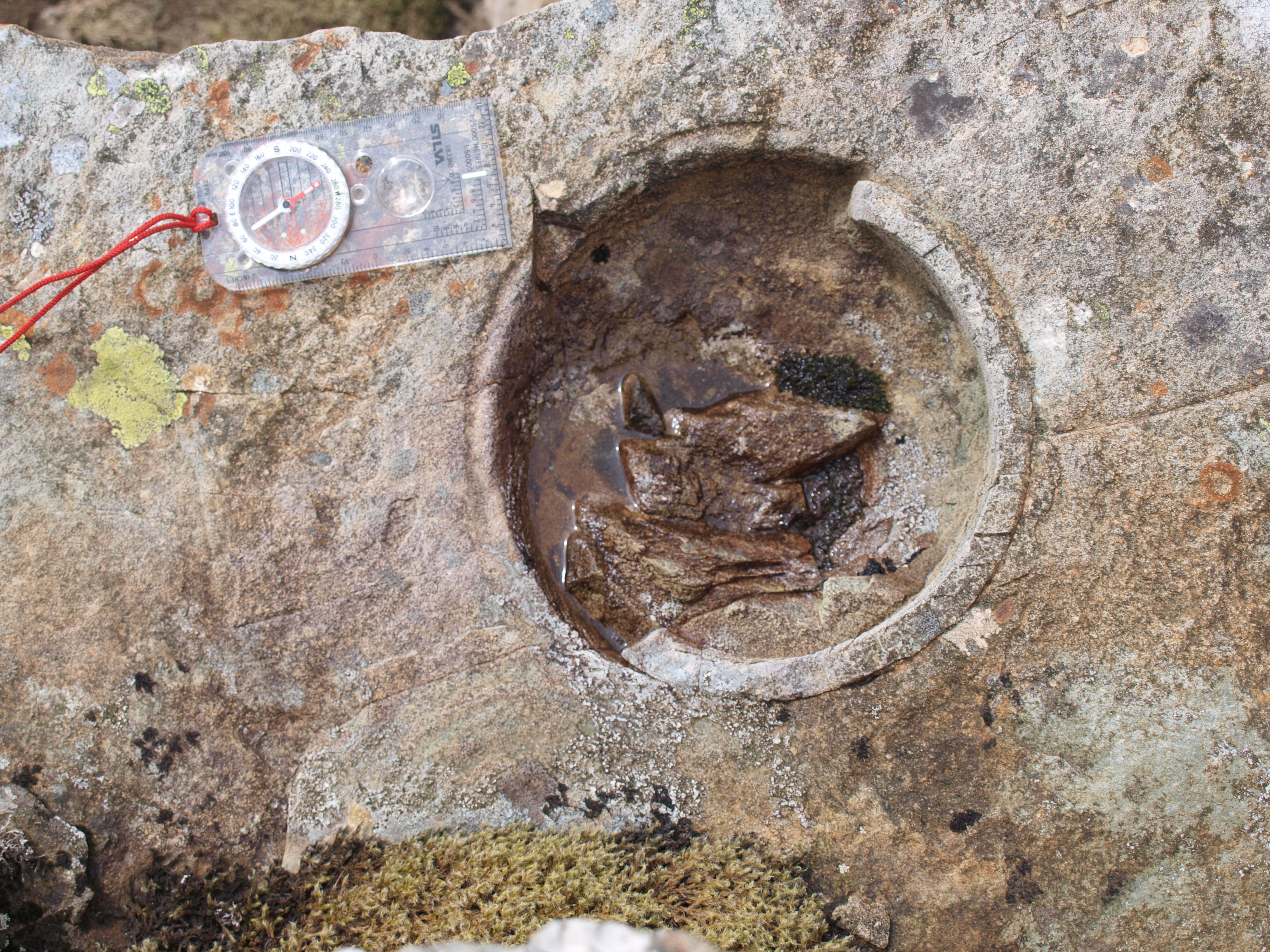
No, not some Mad Hatter-esque question posed at an eccentric tea party in Grasmere, but a serious question that concerns all prehistoric rock art/cup mark researchers. Unlike this picture, today in the Cumbrian Fells this question would be hard to address with a light dusting of snow – the dormice are, well dozing, however the low sun at this time of year is possibly the best opportunity to consider the problem.

Whorny Side cairn 086

“Sun Cup” Loweswater

This came to mind following a field trip to look at some recently reported rock art sites. Among these was a single cup at the top edge of a fine glaciated slab on the side of the valley just above Crummock Water, a site I feel, had it been in Scandinavia would have been covered with ritual carvings of Bronze Age boats or perhaps further north, reindeer.

Buttermere rock art field trip 019

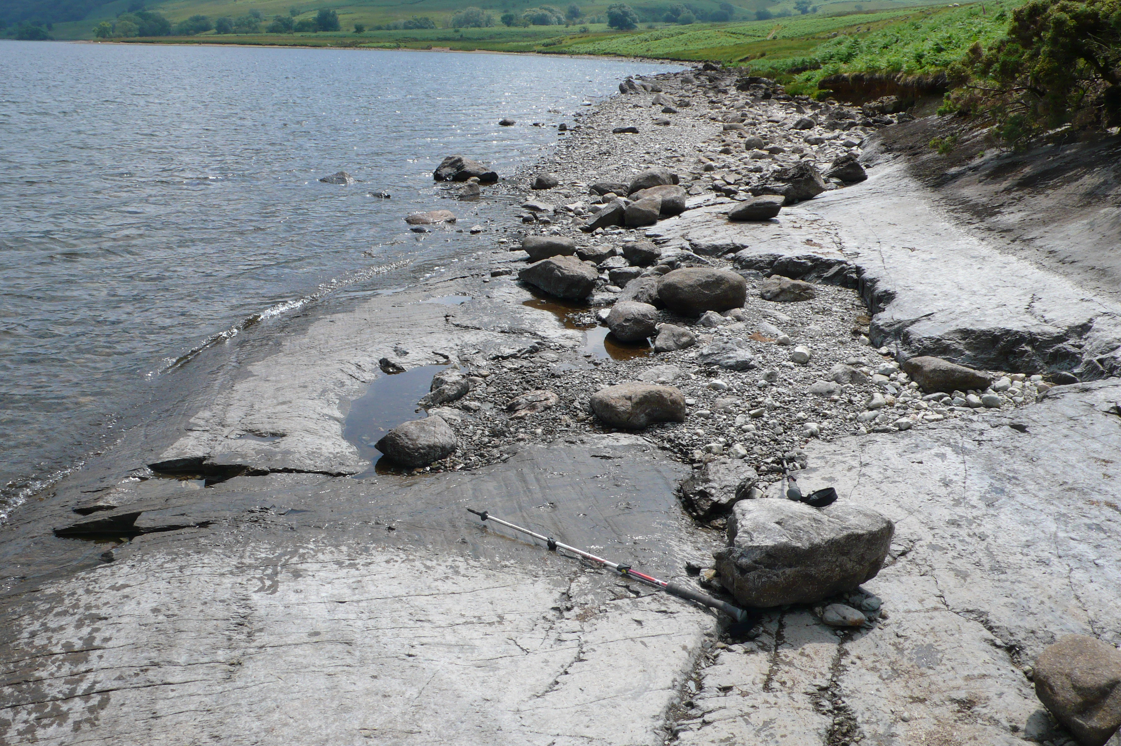
“Cup-marked” glaciated slab, Crummock Water

But this “cup” appeared to sit in splendid isolation in a setting that was somewhat atypical for the locale.

Buttermere rock art field trip 018

Solitary”cup-mark” Crummock Water

It’s base also had a hump, now this in itself does not disqualify it from being a man-made cup, a row of four at Buttermere we had agreed earlier were cups were of rougher manufacture than we expect to see normally, so it could be. But, having previously observed the lower usually submerged slab, when the lake level had dropped considerably a few years ago, it was obvious there were marks that had been plucked out by the glacial action rather than pecked by man. Had these marks been exposed to the elements for many millennia they may well have eroded into what we could see as the single cup mark above. Likewise the four we saw earlier may have eroded smoother had they been on a level rather than sloping surface

Crummock slabs, Ling Crag; Dodd Cairn; Gale Fell; Gable moonrise 016

Glaciated slab, Crummock Water, glacial “plucks” just above pole

So what other criteria do we consider are appropriate to test the veracity of a possible cup mark? One is its landscape setting,  perhaps a little thorny as there are inevitably always exceptions, however we can say with a certain amount of confidence at present that the majority of the sites here are on glaciated bedrock, often roche moutonnée.

Confusingly one of the first sites to be identified in the Lake District on the Langdale Boulders is now appears to be an anomalous site within the region and is surrounded by cupule of natural origin

Allen banks, crummock cups, Castlerigg 022

Eroded clasts, Great Langdale

So what of the actual cupule? Aside from slabs whose surfaces are pitted with eroded glacial gas vesicles or eroded clasts – inclusions of softer rocks – we are left with the case of the odd cup or two that may or may not be of human origin.

Scafell Pike Axe factories 110

Eroded gas vesicles, Scafell Pike

Now a few of these individual cups are of such symmetry that they compare well to slabs where there are numerous other cup-marks.

Mitredale 054

“Cup-marked” rock, Mitredale

But some do not quite cut the mustard; this rock reported as cup marked in a survey of Mitredale has many of the attributes of natural features – eroded faults and “cups” with projecting inclusions – which should have suggested that these were natural features.

Mitredale 050

Eroded “cup” Mitredale

So back to the problem, when a cup is not a cup,  when it is an only cup…

A fine natural bowl from the summit of Haycock

A fine natural bowl from the summit of Haycock

or when it’s a bowl?

Pete


Notes: Thanks to; Jamie Lund, National Trust Archaeologist, Mark Astley, National Trust Ranger, and Tom Bell, Chester University, for discussions on these sites. If you wish to see the solitary “cup” yourself you can find it directly below LIng Crag, Crummock Water, its a fine walk, there are other sites locally that really are prehistoric cups!

Sense of Here

The knowing and feeling of place

tombjorklund.fi

Tom Björklund • Artist and Illustrator

The First Ten Words by Rich Larson

Because a guy has to keep his chops sharp

Palaeoman

Living the dream of a prehistoric human

Archaeology and Heritage Digital Recording

Low cost recording technologies

The Stone Rows of Great Britain

Big, Small, Short, Tall, Have we got 'em all?

northshorepottery

studio pottery and ceramic sculpture by Jenny Mackenzie Ross

Duddon Dig

The survey and excavation of three longhouses in the Duddon Valley

Neil's Mountains

Exploring the mountains and wild places of Britain and Ireland

Archaeology Orkney

UHI Archaeology Institute

Neolithic And Early Bronze Age Research Student Symposium

Annual Conference for Postgraduate Researchers